Blog
-
BC NIMBY Toolkit (Housing / Development Guidelines) and No Public Hearings
🐿️ Squirrel for Mayor Unearthed documents show the use of the word “NIMBY” in BC government publications. Development Approvals Process Review (DAPR, 2019) Direct quote: “Public hearings can enable NIMBY (an acronym for ‘not in my backyard’) which describes residents’ opposition to a development in their own neighbourhood, while raising no objections to similar developments Read more
-

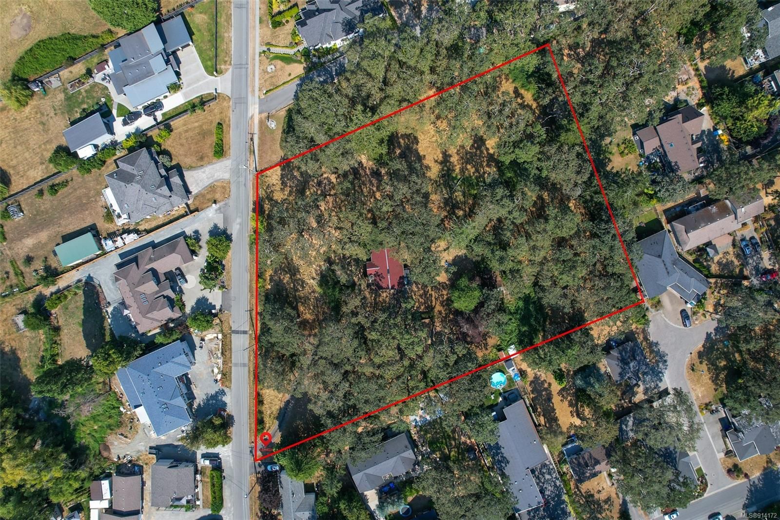
Demand more Garry oaks and their ecosystem are saved on this 903 Admirals Road development
The petition has been started, which calls for stronger protection of Garry oak ecosystems in the proposed 903 Admirals Road development in Esquimalt, highlighting significant ecological loss and insufficient replacement planning. Squirrel for Mayor notes that according to the project’s Appendix C Landscape Plan, the site currently contains 54 trees (with 8 additional off-site trees Read more
-

When Climate Action Loses the Plot: Saanich at McKenzie Roads and the Consequences of Not Thinking with Place
By Squirrel For Mayor At the March 17, 2026 Saanich Council decision approving a rezoning application and development permit for a six-storey condo proposed for the corner of 961 McKenzie and 3986, 3990 Saanich Road, the justification was familiar — and explicitly stated. Loss of Garry oaks, we were told, is the price of protecting Read more
-
When Housing Debates Erase Ecology: The Story of 4015 Braefoot Rd. and the Garry Oak Ecosystem
By Squirrel for Mayor A petition has been created by local resident Yves Parizeau to save numerous Garry Oaks at 4015 Braefoot Rd. in Saanich. The petition has already garnered 1,233 signatures. Sign the Petition In spring 2025, a piece of land in Saanich, BC—two acres of former hobby farm at 4015 Braefoot Rd.—became the Read more
-
What Does It Mean to Live in an Urban Forest?
By Squirrel For Mayor Living in an urban forest isn’t just about having trees nearby or pockets of green space stitched between streets and buildings. It’s about place—and the many spaces required for life to unfold across species, seasons, and scales. In this short video, we see black-tailed deer teaching their young, a Cooper’s hawk navigating food spaces, Read more
-
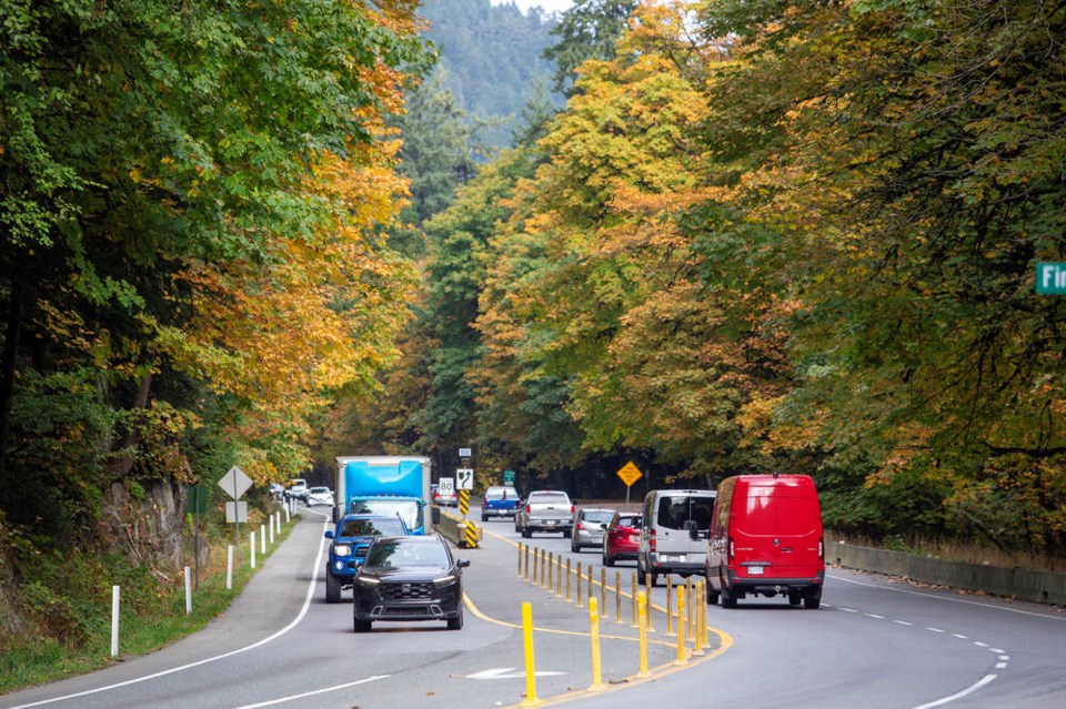
Province nixes Malahat widening through Goldstream Park
The Ministry of Highways and Transportation says additional analysis is required to “understand the potential environmental impacts of the project.” The province said Thursday it will not proceed with a project to widen the Trans-Canada Highway through Goldstream Park, citing the need for more environmental review. The $162 million set aside for the project in Read more
-

Comment: Garry oak ecosystem is under great threat in Saanich, Times Colonist, Feb 03, 2026.
Times Colonist, OpinionFebruary 3, 2026Ryan Senechal https://www.timescolonist.com/opinion/comment-garry-oak-ecosystem-is-under-great-threat-in-saanich-11824300 The dominant species in this area is Garry oak, and casual observations confirm that dozens of other species that co-evolved with this tree species are also present. A commentary by a Saanich resident. Buried on page 135 of Saanich’s Quadra-McKenzie Plan are clues of what is in store Read more
-
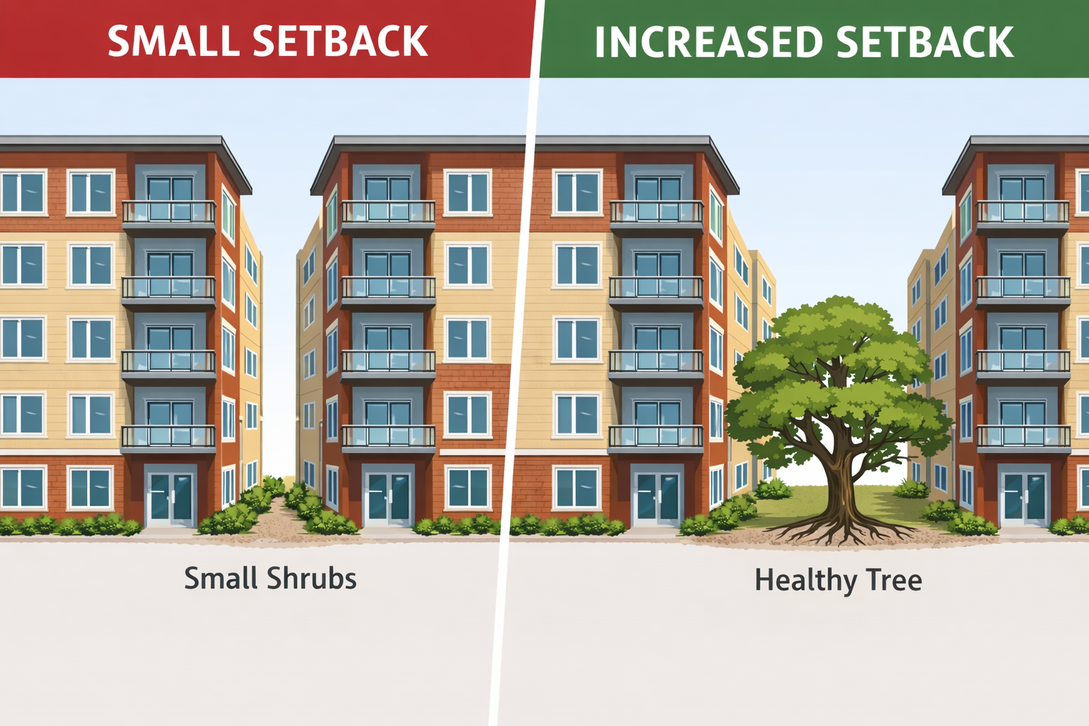
Setbacks, Soil, and Survival: Why Urban Forest Protection in Victoria Starts with Space
By Squirrel for Mayor Setbacks are often treated as a technical zoning detail—numbers on a site plan to be minimized in the pursuit of density. In reality, setbacks are one of the most powerful tools a city has to protect its urban forest, safeguard biodiversity, and uphold climate resilience and public safety. In the City Read more
-
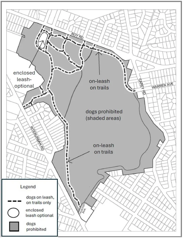
Panama Flats: When Biodiversity and Dog Access Collide — and What Council Decided
By Squirrel for Mayor Panama Flats—a 26-hectare wetland and meadow system in Saanich between Interurban and Carey—has been at the centre of a region-wide conversation about how we share urban nature. On January 12, Saanich Council made an important move by rezoning the Flats as a bird and nature sanctuary, formally recognizing one of the region’s Read more
-
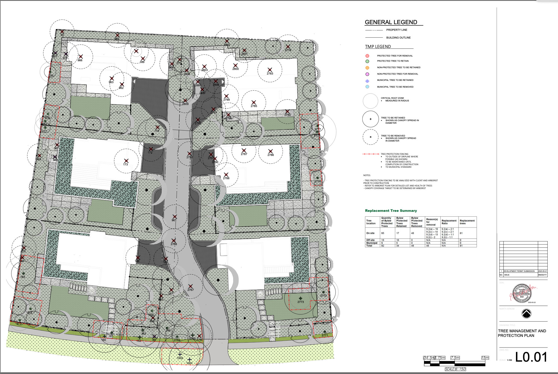
Will Oak Bay Council Allow 48 Bylaw Protected Trees to be Cut for Townhomes in the Uplands? Residents Urge Council to Reject Proposed Development.
By Squirrel for Mayor 2830/2850 Lansdowne Road This proposed development involves two adjacent lots in the Uplands on Lansdowne Road, located on the north side between Ripon Road and Norfolk Road. Both properties are zoned R-2 Residential Use. The purpose of the application is to permit the proposed construction of a Small Scale Multi Unit Read more