Category: Tree Protection & Bylaws

  • Council Member Motion – Urban Forest Canopy

    Council Member Motion
    For the Committee of the Whole Meeting of April 3rd, 2025


    COTW Video segment:
    https://pub-victoria.escribemeetings.com/Meeting.aspx?Id=f613a2e9-ce96-43b6-aca8-b281afcdaf54&Agenda=Merged&lang=English&Item=23&Tab=attachments

    Motion (.pdf)
    https://pub-victoria.escribemeetings.com/filestream.ashx?DocumentId=101687

    BACKGROUND:

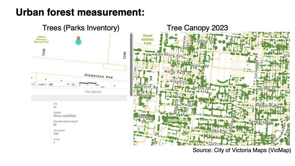
    A significant value for Victorians is nature, our climate, our hills, our natural green areas, and our urban forest. Section 4, Blue Green Networks of the 2025 DRAFT OCP, includes a brief description of the City’s need for attention to the Urban Forest. The Urban Forest city-wide canopy cover is about 28 per cent (Draft OCP).

    The City of Victoria Urban Forest Master Plan (February 2013) recommends that a canopy cover goal of 40% would be appropriate for cities in the Pacific Northwest. Table 1 of that document, citing a 2013 LIDAR analyses, states Victoria’s City Wide Canopy Coverage was 26%.
    (see Appendix for list of reference documents).

    The City’s Tree Protection Bylaw’s (21-035) Tree Reserve cash-in-lieu program receives funds when trees are removed from private property (75% of the urban forest) in order to replace them on public property (25% of the urban forest). While the City performs an appraisal value for trees on public property which could be valued between $6000 and $100,000 per tree to compensate for the value of the tree, installation and maintenance of the replacement tree, the cash-in-lieu fee associated with a deficit of the tree minimum at the end of a project on private land is $2000 per tree.

    Therefore, there are not enough funds collected from private property tree removals to plant and maintain replacement trees on public property. The City cannot replace trees on private land and achieve a 40% tree canopy target by 2050. We recognize higher costs that the City will need to increase costs for maintenance of trees removed from private property and maintained on public property.

    An increase in fees for cash-in-lieu would incentivize developers to replace more trees and conversely, to disincentivize expedient tree removal.
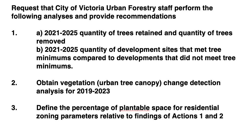
    RECOMMENDATIONS:

    That Council direct staff to

    1. Set 5-year tree canopy (growth) targets within the OCP supporting a 40% city-wide 2050 tree canopy goal.
    2. Set five-year neighbourhood-level planting targets within the OCP to reach a 40% tree canopy by 2050.

    3. Raise cash-in-lieu fees when a development does not meet the Tree Protection Bylaw tree minimum on private property from $2000 to $5000 per tree to go into the Tree Reserve Fund, to reach 40% tree canopy by 2050.

    Outcome:

    1. Set 5-year tree canopy (growth) targets within the OCP supporting a 40% city-wide 2050 tree canopy goal. (APPROVED)

    2. Set five-year neighbourhood-level planting targets within the OCP to reach a 40% tree canopy by 2050. (APPROVED – Amended to add “city-wide” to indicate that the Neighbourhood targets can vary from 40% but contribute to the city average of 40% and passed 5 to 3, Dell, Kim, and Thompson voted against.)

    3. Raise cash-in-lieu fees when a development does not meet the Tree Protection Bylaw tree minimum on private property from $2000 to $5000 per tree to go into the Tree Reserve Fund, to reach 40% tree  canopy by 2050. (This has been moved to a later date so that staff can report back)

    Additional Information

    The relationship between land use development and tree canopy is a dynamic one; each influences the other. Our community’s aspirations for the future, as outlined in the Official Community Plan (OCP), reflect our values. The Urban Forest Master Plan lays out specific goals that guide us toward realizing this vision. Trees, particularly those on private properties, play a crucial role in enhancing the ecosystem services that benefit our residents. By increasing the cash-in-lieu fee from $2,000 to $5,000 per tree that falls short of the required minimum, we create a strong incentive for developers to comply with the Tree Protection Bylaw rather than diminishing our community’s green resources. Even the addition of a single tree per development can have a meaningful impact on our ecosystem without incurring costs for the city in terms of planting and maintenance.

    Cash-in-lieu charges are for each tree that does not meet the required minimum on a property at a 1:1 ratio. This approach differs from the 3:1 tree retention credit ratio that encourages the preservation of large, healthy specimen trees. It’s important to note that trees retained and replacements made to meet the minimum requirements are exempt from these cash-in-lieu charges.

    While the City recognizes the value of trees on public lands when calculating ecosystem services, cash-in-lieu payments have not successfully compensated for tree loss. Over the past three years, the City has collected $1,047,000 from developments that fell short of the tree minimum, resulting in a net loss of 523 trees from private properties. The cost of planting trees in boulevards is at least $1,250 each, and in areas with hardscaping, like linear parks, the cost rises to $10,000 or more, not to mention the ongoing maintenance required. Many municipalities still use outdated cash-in-lieu fees that don’t reflect the actual costs of planting trees on public land, leading them to operate at a loss. By raising these fees, the City of Victoria can enhance tree canopy growth, discourage unnecessary tree removals on private properties, and better support the budget necessary for maintaining ecosystem services provided by City staff on public land.

    There are important points, and assist towards a positive impact on residents’ physical and mental health and a greener, more sustainable community. 

    Deliberation related to neighbourhoods:
    Derrick Newman, City of Victoria Director of Parks, wants to look at neighbourhood typology rather than “artificial boundaries within the city limits.” Councillor Caradonna said that the “point of the one city OCP is to move away from neighbourhood level plans, and what I’m seeing and hearing from staff is that number 2 creates a lot of challenges because then we’re back to figuring out what’s going on at the neighbourhood level,” and that he “does not want to move us backwards to neighbourhood plans.”

  • City of Victoria’s 2019-2023 LiDAR vegetation change detection analysis

    The City of Victoria’s Urban Forest Canopy Analysis from 2019 to 2023 was posted on Wednesday, April 02, 2025.

    Data

    Explore the tree canopy change across the City on  VicMap . You’ll find layers for tree canopy measurements taken in 2013, 2019, and 2023 in the layer list under Environment. 

    The Tree Canopy TIF images are available on our Open Data Portal ( opendata.victoria.ca ):

    The 2019 LiDAR was provided by  LiDAR BC  and can be downloaded directly from their website. The 2013 and 2023 LiDAR datasets are too large to share on our Open Data Portal. LiDAR data requests indicating an area of interest can be sent to GIS@victoria.ca. LiDAR analyses for these projects were performed by Terra Remote Sensing Inc. located in Sidney, BC.

    Background

    The City has measured urban forest canopy cover using LiDAR (Light Detection and Ranging) technology since 2013. Measurements were taken in 2013, 2019 and 2023 using consistent methodology to ensure accuracy and comparability.

    LiDAR generates detailed 3D models to assess the horizontal and vertical growth of trees while filtering out low vegetation and built infrastructure. The technology is detailed, accurate, and comprehensive in classifying vegetation above two metres.

    Status

    The City’s total tree canopy cover grew from 26 per cent to 30 per cent between 2013-2023, an increase of approximately 70 hectares, or more than 100 soccer fields. Importantly, the data shows growth in all neighbourhoods across the City.

    This increase is primarily associated with healthy, existing, mature trees. This trend also suggests that the City’s long-term approach to urban forest management has been effective, and that trees are being managed well on private property (75% of the urban forest).

    Additional details are now available on the City’s website which illustrate the tree canopy change over time and explain how canopy is measured using LiDAR. The map and downloadable data are available at the City’s story map website.

    Critical review

    Initial reflections of City of Victoria’s 2019-2023 LiDAR vegetation change detection analysis

    -The rate of urban forest growth fell by 50% from the previous period of analysis (2013-2019)

    -The urban forest net gain was +47.4 hectares between 2013-2019 (+2.37% to 28.83% city-wide), and according to the City’s website an additional net gain occurred in 2019-2023 of +24 hectares (1.17% to 30% city-wide).

    -Terra Remote Sensing provided comment on the 2013-2019 COV change detection analysis, and it is  relevant to reflect as the rate of growth drops by 50%: ” It will be of importance to monitor the continual changes in the city’s vegetation canopy to assess whether the fill in growth of existing and new plantings will continue to outstrip the vegetation loss. Further to on-going monitoring, determining age class, distribution, and species composition will help to forecast vegetation growth trends and potentially predict when vegetation growth will cease to offset losses.”

    – In four short years we are 23 hectares short of the previous four years’ urban tree canopy growth rate. COV Parks notes “A consistent finding is that the growth of healthy mature trees offsets canopy lost due to development, extreme weather, decline and disease.”, but it’s important to reflect on the slowing rate of growth.

    – Limitations: the only information provided by the City on the 2019-2023 canopy gain is “From 2013-23, Victoria’s tree canopy grew by about 70 hectares, which is more than 100 soccer fields”.

    The numbers look a lot better over 2013-2023 than 2019-2023. We can see the momentum of canopy growth vs. canopy loss is shrinking fast, and we could soon revisit the 2007-2013 period which produced a net gain of .05% (1 hectare). It’s below the margin of error for the analysis methods.

    -The conversation around the City’s potential adoption of a goal to achieve 40% canopy cover city-wide should consider 2019-2023’s halving of the canopy growth rate.

    Canopy goals should be achievable: you cannot get to 40% if the rate continues to slow and we approach 0% or a net loss scenario.

  • Presentation to Council- Urban Forest and Natural Assets, City of Victoria

    Presentation: Thursday, March 13, 2025 at 6:30 P.M. Council Chambers

    E. Request to Address Council

    E.7 Urban Forest and Natural Assets (LiDAR) update for Draft OCP “Victoria 2050”

    Video Link: https://pub-victoria.escribemeetings.com/Meeting.aspx?Id=22a0de46-6b14-4887-83fe-114fa79ced8d&Agenda=Merged&lang=English&Item=29&Tab=attachments

    Documents:

    The City of Victoria has collected urban tree canopy data over multiple years by to perform ongoing measurements of its urban forest canopy. The City has outsourced urban tree canopy monitoring (i.e., vegetation) twice the past, measuring between 2007-2013 and 2013-2019. This process should be repeated with the recently obtained urban tree canopy measurement capture in LiDAR for 2023. By doing so, there will be better understanding of how the urban forest has been impacted by development policies and practices between 2019 and 2023.

    The results of urban forest monitoring compares urban forest measurements over time and clarifies how present land use development policies and the Tree Protection Bylaw interrelate. This analysis is integral to understanding proposed changes to the Official Community Plan (OCP) and the potential for neighbourhood level urban tree canopy loss over the medium to long term.

    Research supports how deficiencies in tree canopy at the neighborhood-level

    a) diminish residents’ physical and mental health outcomes;
    b) removes wildlife habitat and reduce overall species diversity; and
    c) reduces ecosystem services capacity, for example, provision of surface shading during heatwaves and reducing peak stormwater flows.

    From 2013 to 2019, Victoria’s urban forest grew by 2.37%, achieving a citywide canopy cover of 28.8%. The growth measured during this period predates the updated Tree Protection Bylaw (21-035) and adoption of required tree minimums through the development process.

    The Tree Protection Bylaw has not been updated since the introduction of City of Victoria’s Missing Middle Housing Initiative and the Province of BC Bills 44 and 37. This is significant, because housing policies which prioritize the built environment can undermine physical protections for trees and tree minimums thru developments established in the Tree Protection Bylaw – and the families of wildlife trees support.

    The targeted tree density (i.e., “tree minimum) established in the Bylaw have so far not been evaluated for effectiveness. This approach to urban forestry stewardship through urban development is theoretical. It lacks empirical evidence to support its effectiveness and continued application.

    Over 75% of the urban forest is on private property. While the Tree Reserve Fund has collected nearly 1.8 million dollars from January 2021 to March 2024, The accumulation of funds in the Tree Reserve between 2021-2023 is evidence of that ineffectiveness. In only 3 years the City accumulated $1,047,000 from developments that could not achieve the tree minimum, which equals net deficit of 523 trees from private property.

    The release of 2023 LiDAR data, and the City’s own Tree Protection Bylaw metrics concerning tree removal and replacement related to development presents a timely opportunity to update urban forest monitoring. Analyzing changes from 2019 to 2023 will improve City of Victoria’s understanding of existing urban forest policies and the links to land use development changes over the past five years. This will also help inform Bylaw modernization, and improve the potential for realizing the goals set forth in the “Victoria 2050” vision and in the Urban Forest Master Plan.

    On behalf of the RNA LUC, 

    we offer the following recommendations to Mayor and Council as part of the OCP review process:

    Slide 3 We request that City of Victoria Urban Forestry staff perform the following data analyses and provide recommendations to incorporate in the Draft OCP “Victoria 2025.”

    1. a) 2021-2025 neighbourhood-level metrics on quantity of trees retained and quantity of trees removed through developments, and b) 2021-2025 neighbourhood-level metrics on quantity of development sites that met Tree Protection Bylaw tree minimums compared to developments that did not meet the Tree Protection Bylaw tree minimums.
    2. Obtain vegetation (urban tree canopy) change detection analysis for 2019-2023 using the methods of previous monitoring surveys conducted by Terra Remote Sensing
    3. Define the percentage of plantable space for residential zoning parameters relative to findings of Actions 1 and 2.